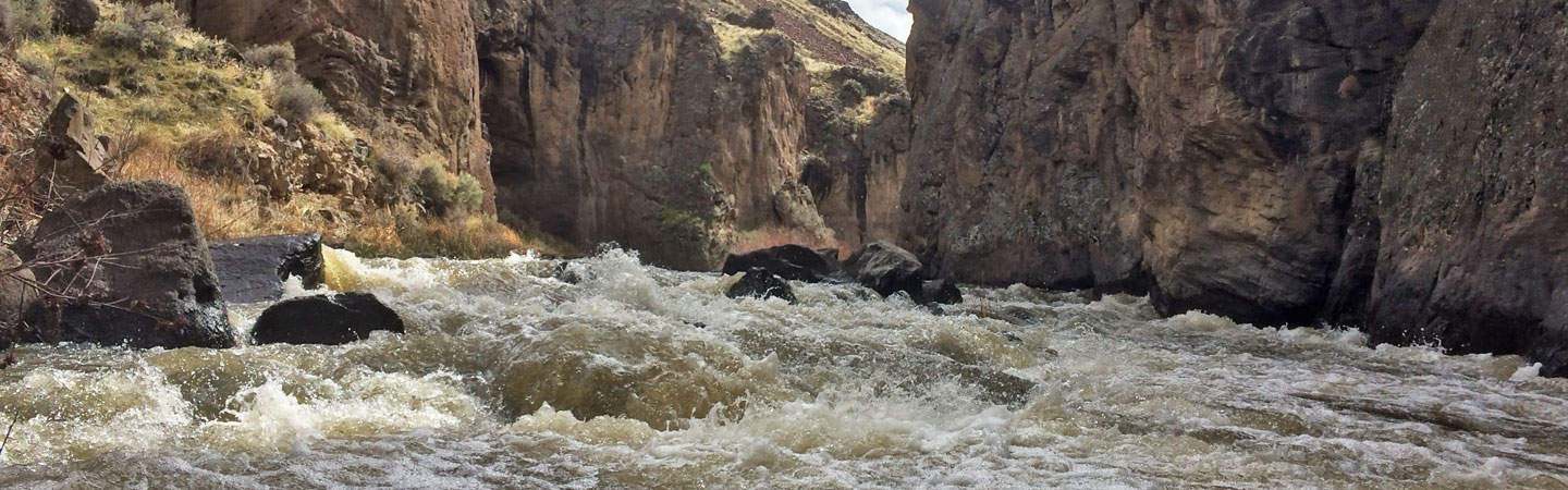
The Jarbidge and Bruneau rivers of Southern Idaho provide paddlers with one of the most stunning, unique and splendid canyons in the western United States. Other provisions include a boxed-in committing feel, a 2 hour, one-way shuttle on dirt roads through one of the least inhabited spots in the Lower 48, ample wildlife and some sparing class IV and (portageble) Class V whitewater. Despite these short difficult sections, the run is largely Class III-IV.
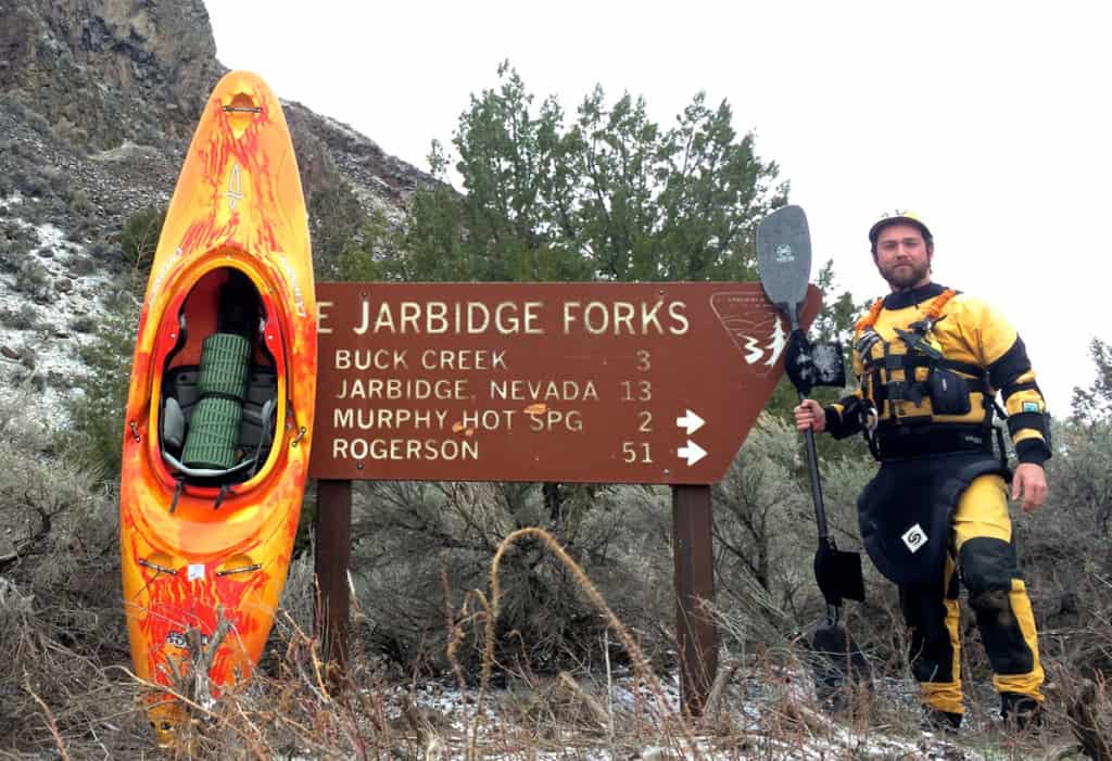
At Put-in for the Jarbidge - Bruneau
The Jarbidge river starts out as a small river, only a fraction of what it will become on the lower Bruneau. One of the joys of the stretch is watching the river grow throughout the run. At low water, the river is narrow and shallow with a lot of busy Class II and III spots in the first 15 miles. Keep heads-up for wood in this section.
Trip Description
Mile 0: Put-in at the Jarbidge Forks.
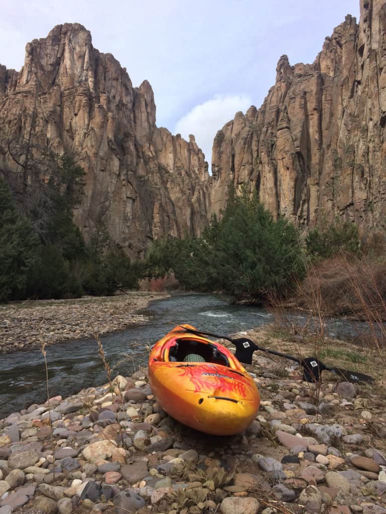
The Jarbidge River Canyon
Miles 15 through 17: Difficulty starts to increase. After a series of Class III rapids a lake forms in which a number of juniper pines have been flooded and are dead or dying. This is the former sight of Sevy Falls and the effects of a rock slide that has created an earthen dam and a new rapid. The BLM is calling it, "Castle Grayskull". Other names include Tonsmeire Falls, Barker Falls and Vanity Falls.
As all new rapids do, this one will continue to settle and change with time. In March of 2016, with 1000 cfs on the Bruneau gauge, the water was draining through a channel on the far river-left side. There was a tight Class IV lead-in to a double drop of about 6 and 4 feet. While there was wood in the lead-in, the double-drop was clean. The rapid is definitely Class V and surely becomes more difficult with more water. Portages are difficult on both sides and water level dependent.
Below the rock slide the river tightens up and moves through a narrow section of Class III called Tonsmeire Torrent, named after some pioneers of the run. At Mile 18.6 on river-left, Cougar Creek comes in. There are fine camps in this area and a 3-mile hike up the canyon to an arch.
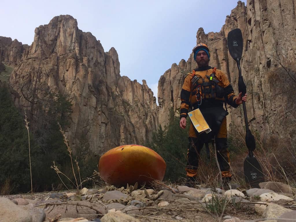
The lonely canyon and the paddler
Note: From Mile 16 to Mile 27 the Jarbidge maintains a fairly continuous Class III or higher difficulty. Game on!
Mile 21.4: The next significant rapid is Wally’s Wallow at Mile 21.4. The beginning of this rapid forces a sharp move to river-right around a mid-channel boulder before a busy run-out. Other notable rapids in this stretch include a series of Class IV drops entitled, The Maze, Labyrinth, and John’s Jollies around Mile 25.
Mile 26.3: Be on the look-out for Jarbidge Falls at Mile 26.3. At low water, this rapid is an impassable sieve. At high water the lines open up a bit, but the rapid is still Class V. A difficult portage exists on river-left. After Jarbidge Falls the river eases up in its intensity.
Mile 29.5: The confluence with the West Fork of the Bruneau and the beginning of the Bruneau River itself occurs at Mile 29.5.
Mile 30.2: At Mile 30.2, on river-left, the steam from Indian Hot Springs can be seen. Be sure to stop here and soak in the old bath tub serviced by a hose coming down from the springs on the hillside. There is a rickety old bridge leading over to the Bruneau launch site and and the road out of the canyon (eventually leading to Clover-Three Creek Road). Be sure to check out the old stagecoach building up above the hot springs too.
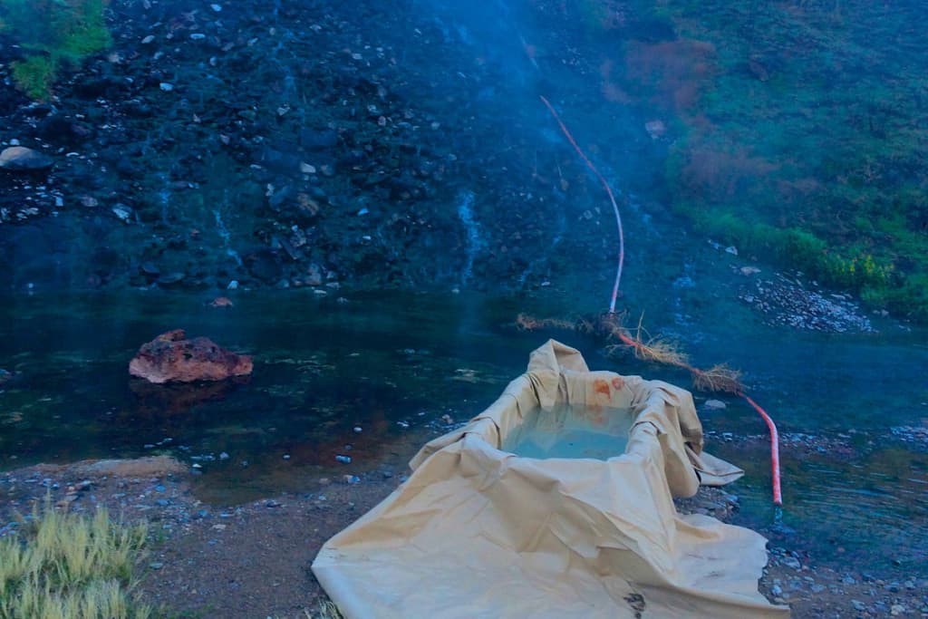
Indian Hot Springs
After the confluence the Bruneau meanders through a park near Indian Hot Springs for less than two miles before it enters the rhyolite gorge which sustains for over 35 miles. The Bruneau exhibits its steep, stunning and vertical volcanic walls in a dramatic canyon. From Mile 31 through 60.9 the river never exceeds Class III in difficulty at most flows.
Mile 60.8: The Roberson Trail provides exits to the canyon on both river-left and river-right. This is your last chance to leave the canyon before the Class IV, Five Mile Rapids. Locals run day trips from here.
Mile 61.9: Finally, at Mile 61.9, Boneyard rapid begins the Five Mile Rapids, which are really about 3 miles of intermittent Class IV with another mile or so of Class III after that. This five-mile stretch consists of a series of Class IV rapids including Hughes Horn, Devil’s Garden and Nemesis among others. This is the crux of the Bruneau. After the Five Mile Rapids the Bruneau eases up a bit until Mile 67.8 where Wild Burro rapid proved to be the grand finale of the run, a long Class III-IV send off. Look for the Bruneau River Hot Springs on river-left not far above the take out (approx. Mile 71).
There is a gauge on the Upper West Fork of the Jarbidge, near Jarbidge, Nevada, however, most boaters use the gauge on the Bruneau near the Bruneau take-out as a barometer for the Jarbidge run. A minimum for kayaks is around 500 cfs on the Bruneau gauge and 1000 to 1500 for rafts, depending on how much you are willing to beat up your boat and drag it over a few pinches.
The elevation of the Jarbidge put-in is around 5000 feet above sea level, the Bruneau take out is close to 2500 feet, making the total drop of the run 2500 feet in 71 miles or a gradient of about 35 feet per mile.
Make sure to pick up a copy of the BLM's "Owyhee, Bruneau, and Jarbidge Rivers Boating Guide" from one of the four district offices in Boise or Twin Falls, Idaho; Vale, Oregon; or Elko, Nevada. You can also purchase one and have it sent to you before your trip.
There is a way to run each canyon separately, however, it entails navigating one of the infamous Bruneau territory 4-wheel-drive roads down to Indian Hot Springs. This road is for vehicles with four-wheel drive and high clearance only. If you attempt any of the roads in the Bruneau territory bring a jak, a spare tire or two and a shovel. They are no joke.
For this reason, access to and from the stretch is best done by running both the Jarbidge and the Bruneau canyons together, in a 3 – 5 day, 71 mile trip.
Shuttle
From the town of Bruneau, Idaho, head southeast on Hot Springs Road for exactly 8.4 miles. Here, Clover-Three Creek road begins and veers off to the east. To set the shuttle at the take-out veer to the right at this junction and proceed for 0.6 more miles. There is an established take-out on private land here, essentially a road leading to the river bank through a pasture with a BLM sign, just upstream of a dangerous low head dam. No camping.
Before venturing out across the desert, I recommend topping off your gas tank in Bruneau. Remember, the shuttle is 70 miles in one direction and there is no gas station out there, including Murphy Hot Springs. To access the put-in, return to Clover-Three Creek Road and head south-bound on the road for 60 miles across the Bruneau and Inside Deserts. You will also cross twelve miles of the Saylor Creek Air Force Range en route so consider yourself a moving target…
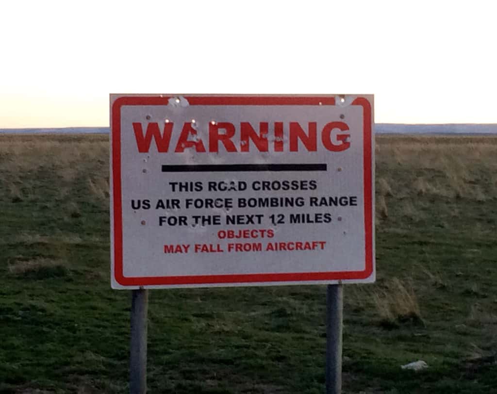
Warning Sign
After 59 miles Clover-Three Creek road will end and you will want to turn right or southwest on Three Creek Road. Soon you will descend into the East Fork Jarbidge Canyon and pass by the peculiar town of Murphy Hot Springs. Keep heading downstream. Two miles past Murphy Hot Springs is Jarbidge Forks, the BLM put-in for the run, where the East and West Forks of the Jarbidge confluence. The distance between the Clover-Three Creek / Three Creek road junction and Jarbidge Forks is 10 miles which makes the shuttle, from take-out to put-in, 70 miles, the same distance as the run itself.
On March 30, 2009, President Barack Obama signed the Omnibus Public Land Management Act into law, which designated 317 miles of the Owyhee and Burneau drainages as Wild, Scenic or Recreational Wilderness. The Jarbidge and Bruneau rivers were including in this protection.